Zum Hauptinhalt springen

Suchergebnisse

Katalog
Ermittle Trefferzahl…

Discovery Service
495 Treffer

Suchmaske

Suchtipp für den Bereich Discovery Service: Wörter werden automatisch mit UND verknüpft. Eine ODER-Verknüpfung erreicht man mit dem Zeichen "|", eine NICHT-Verknüpfung mit einem "-" (Minus) vor einem Wort. Anführungszeichen ermöglichen eine Phrasensuche.
Beispiele: (burg | schloss) -mittelalter, "berufliche bildung"

Suchergebnisse einschränken oder erweitern

Erscheinungszeitraum

Mehr Treffer

Weniger Treffer

Art der Quelle

Thema

Verlag

Sprache

Geographischer Bezug

Inhaltsanbieter

495 Treffer

Sortierung: 
  1. Ciołkosz, Andrzej (1939- ). ; Ciesielski, Jan Bronisław (1921-2015). ; et al.
    1980
    Karte
  2. (Covers to) A new sett of maps both of antient and present geography : wherein not only the latitude and longitude of many places are corrected, according to the latest observations ; but also the most remarkable differences of antient and present geography may be quickly discern'd by a bare inspection or comparing of correspondent maps ; which seems to be the most natural and easy method to lead young students (for whose use the work is principally intended) unto a competent knowledge of the geographic science. Together with a geographical treatise particularly adapted to the use and design of these maps. By Edward Wells ... Imprimatur, Gu. Paynter Vice-Can. Oxon. London: Printed by T.W. for J. Walthoe, R. Wilkin, J. and J. Bonwicke, S. Birt, T. Ward and E. Wicksteed. : A new sett of maps both of antient and present geography : wherein not only the latitude and longitude of many places are corrected, according to the latest observations ; but also the most remarkable differences of antient and present geography may be quickly discern'd by a bare inspection or comparing of correspondent maps ; which seems to be the most natural and easy method to lead young students (for whose use the work is principally intended) unto a competent knowledge of the geographic science. Together with a geographical treatise particularly adapted to the use and design of these maps. By Edward Wells ... Imprimatur, Gu. Paynter Vice-Can. Oxon. London: Printed by T.W. for J. Walthoe, R. Wilkin, J. and J. Bonwicke, S. Birt, T. Ward and E. Wicksteed. : Covers: A new set of maps both of antient and present geography
    Wells, Edward, 1667-1727 ; Burghers, M. ; et al.
    1700
    Online Karte
  3. (Title Page to) A new sett of maps both of antient and present geography : wherein not only the latitude and longitude of many places are corrected, according to the latest observations ; but also the most remarkable differences of antient and present geography may be quickly discern'd by a bare inspection or comparing of correspondent maps ; which seems to be the most natural and easy method to lead young students (for whose use the work is principally intended) unto a competent knowledge of the geographic science. Together with a geographical treatise particularly adapted to the use and design of these maps. By Edward Wells ... Imprimatur, Gu. Paynter Vice-Can. Oxon. London: Printed by T.W. for J. Walthoe, R. Wilkin, J. and J. Bonwicke, S. Birt, T. Ward and E. Wicksteed. : A new sett of maps both of antient and present geography : wherein not only the latitude and longitude of many places are corrected, according to the latest observations ; but also the most remarkable differences of antient and present geography may be quickly discern'd by a bare inspection or comparing of correspondent maps ; which seems to be the most natural and easy method to lead young students (for whose use the work is principally intended) unto a competent knowledge of the geographic science. Together with a geographical treatise particularly adapted to the use and design of these maps. By Edward Wells ... Imprimatur, Gu. Paynter Vice-Can. Oxon. London: Printed by T.W. for J. Walthoe, R. Wilkin, J. and J. Bonwicke, S. Birt, T. Ward and E. Wicksteed. : Title Page: A new set of maps both of antient and present geography
    Wells, Edward, 1667-1727 ; Burghers, M. ; et al.
    1700
    Online Karte
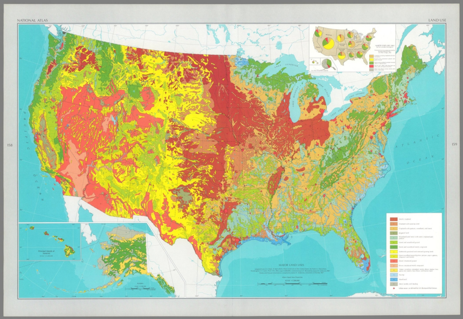
  4. adapted from U. S. Dept. of Agriculture, Major land uses in the United States, by Francis J. Marschner, Washington, U. S. Govt. Print. Off., 1950, map 1:5,000,000, conterminous U. S. Revised by James R. Anderson, 1967. Alaska and Hawaii information compiled by James R. Anderson, University of Florida, 1967.<br />The national atlas of the United States of America. United States Department of the Interior Geological Survey, Washington, D. C. 1970.<br />Major land uses.
    1967
    Online Karte
  5. Cleobury, Miss. ; Wilkinson, R.
    1815
    academicJournal
  6. Cleobury, Miss. ; Wilkinson, R.
    1815
    academicJournal
  7. Cleobury, Miss. ; Wilkinson, R.
    1815
    academicJournal
  8. Cleobury, Miss. ; Wilkinson, R.
    1815
    academicJournal
  9. Cleobury, Miss. ; Wilkinson, R.
    1815
    academicJournal
  10. (Title Page to)The roads through England delineated, or, Ogilby's survey : revised, improved, and reduced to a size portable for the pocket by John Senex, F.R.S. : being an actual survey of all the principal roads of England and Wales, distinctly laid down on one hundred and one copper plates on which are delineated all the cities, towns, villages, hills, rivers, brooks churches capital seats, and every place worthy of note, throughout each road ; with the addition of some roads newly drawn, which were omitted by Mr. Ogilby, and several necessary corrections made in others ; together with a great number of explanatory references, by which this edition of the roads is rendered of more general use for travellers. Publish'd ... 1st May 1780, by R. Wilkinson ... Cornhill, London. : The roads through England delineated, or, Ogilby's survey : revised, improved, and reduced to a size portable for the pocket by John Senex, F.R.S. : being an actual survey of all the principal roads of England and Wales, distinctly laid down on one hundred and one copper plates on which are delineated all the cities, towns, villages, hills, rivers, brooks churches capital seats, and every place worthy of note, throughout each road ; with the addition of some roads newly drawn, which were omitted by Mr. Ogilby, and several necessary corrections made in others ; together with a great number of explanatory references, by which this edition of the roads is rendered of more general use for travellers. Publish'd ... 1st May 1780, by R. Wilkinson ... Cornhill, London. : Title Page: The roads through England
    Senex, John (1680-1740) ; Wilkinson, Robert ; et al.
    1780
    Online Karte
  11. Cleobury, Miss. ; Wilkinson, R.
    1815
    Online Karte
  12. Cleobury, Miss. ; Wilkinson, R.
    1815
    Online Karte
  13. Cleobury, Miss. ; Wilkinson, R.
    1815
    Online Karte
  14. Cleobury, Miss. ; Wilkinson, R.
    1815
    Online Karte
  15. Cleobury, Miss. ; Wilkinson, R.
    1815
    Online Karte
  16. (Index Page to)The roads through England delineated, or, Ogilby's survey : revised, improved, and reduced to a size portable for the pocket by John Senex, F.R.S. : being an actual survey of all the principal roads of England and Wales, distinctly laid down on one hundred and one copper plates on which are delineated all the cities, towns, villages, hills, rivers, brooks churches capital seats, and every place worthy of note, throughout each road ; with the addition of some roads newly drawn, which were omitted by Mr. Ogilby, and several necessary corrections made in others ; together with a great number of explanatory references, by which this edition of the roads is rendered of more general use for travellers. Publish'd ... 1st May 1780, by R. Wilkinson ... Cornhill, London. : The roads through England delineated, or, Ogilby's survey : revised, improved, and reduced to a size portable for the pocket by John Senex, F.R.S. : being an actual survey of all the principal roads of England and Wales, distinctly laid down on one hundred and one copper plates on which are delineated all the cities, towns, villages, hills, rivers, brooks churches capital seats, and every place worthy of note, throughout each road ; with the addition of some roads newly drawn, which were omitted by Mr. Ogilby, and several necessary corrections made in others ; together with a great number of explanatory references, by which this edition of the roads is rendered of more general use for travellers. Publish'd ... 1st May 1780, by R. Wilkinson ... Cornhill, London. : Index Page: (Continues) Index of all cities ...
    Senex, John (1680-1740) ; Wilkinson, Robert ; et al.
    1780
    Online Karte
  17. (Covers to)The roads through England delineated, or, Ogilby's survey : revised, improved, and reduced to a size portable for the pocket by John Senex, F.R.S. : being an actual survey of all the principal roads of England and Wales, distinctly laid down on one hundred and one copper plates on which are delineated all the cities, towns, villages, hills, rivers, brooks churches capital seats, and every place worthy of note, throughout each road ; with the addition of some roads newly drawn, which were omitted by Mr. Ogilby, and several necessary corrections made in others ; together with a great number of explanatory references, by which this edition of the roads is rendered of more general use for travellers. Publish'd ... 1st May 1780, by R. Wilkinson ... Cornhill, London. : The roads through England delineated, or, Ogilby's survey : revised, improved, and reduced to a size portable for the pocket by John Senex, F.R.S. : being an actual survey of all the principal roads of England and Wales, distinctly laid down on one hundred and one copper plates on which are delineated all the cities, towns, villages, hills, rivers, brooks churches capital seats, and every place worthy of note, throughout each road ; with the addition of some roads newly drawn, which were omitted by Mr. Ogilby, and several necessary corrections made in others ; together with a great number of explanatory references, by which this edition of the roads is rendered of more general use for travellers. Publish'd ... 1st May 1780, by R. Wilkinson ... Cornhill, London. : Covers: The roads through England
    Senex, John (1680-1740) ; Wilkinson, Robert ; et al.
    1780
    Online Karte

Weitere Kataloge

xs 0 - 576
sm 576 - 768
md 768 - 992
lg 992 - 1200
xl 1200 - 1366
xxl 1366 -